Hydraulic Simulation of Extreme Flow and Flood Maps in Uruguay River Reach, in Uruguaiana Municipality, Rio Grande do Sul, Brazil.
Abstract
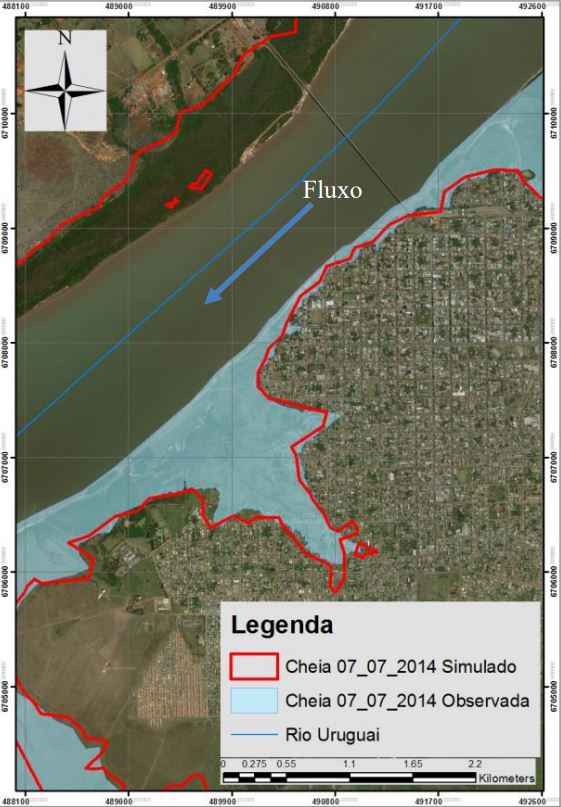
The growth of urbanized areas in Brazil has taken place in an accelerated way and, in most cases, it occurs without the proper approach on issues related to urban drainage and the delimitation of flood risk areas. There is an increasing on the number of records related to damages and losses caused by floods in cities where people occupy the natural floodplain region. As an alternative to stimulate the relocation of housing situated in natural floodplain areas which are frequently affected by floods, the Federal Government issued The Inter-Ministerial Order (Ministry of National Integration and Ministry of Cities) N. 01/2013. As established in this regulation, in case of flood, with the official recognition of the emergency situation by the Federal Government, the affected municipality should present to the Ministry of National Integration a map with flood risk areas possibly affected by different return periods of events. Among other documents, this information is required so that the Federal Government should provide financial support to relocate houses affected by the event. However, since the publication of this regulation, it has been observed that most of the Brazilian municipalities have great difficulties in presenting such studies, mainly because of technical limitations and lack of resources to hire field survey and data acquisition. In this way, the present work shows a case study in Uruguaiana/RS municipality, in a reach of Uruguai River, which is regularly affected by floods, employing free topographical data from SRTM images, free flow data from National Water Agency data bank and the free hydraulic model- HEC-RAS, from the US Army Corps of Engineers. As result, the study presents a flood map with different return periods and the associated flow.